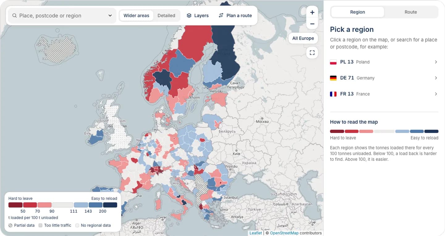
Freight balance map of Europe
See where trucks find a load back. Each region shows how much freight leaves compared with what arrives, so you can plan the return before you accept. The interactive map opens with a code from our TikTok.
Data: Eurostat road freight statistics, 2024 and 2025.
Unlock the interactive map
The interactive map opens with a code from the Logifie TikTok.
Get a code on TikTok (Opens in a new tab)How to read it
Each region is classed by one number: tonnes loaded there for every 100 tonnes unloaded there. Below 100, more freight arrives than leaves, so leaving with a load is harder. Above 100, more freight leaves than arrives, so reloading is easier. Choose a region to see its verdict, then check a route to see the start, the end and the nearest better reload areas.
What the numbers are
The figures are road freight loaded and unloaded in each region in 2024 and 2025, in tonnes, not trucks. Domestic hauls by hauliers of the region's own country are removed, so what remains is cross-border and foreign-truck freight, including cabotage, which is a real reload for a foreign truck. Each verdict has a confidence badge (Steady, Mixed or Unsteady) that compares the two years. Regions are classed with the Eurostat NUTS regions of the data version shown on the map. Overseas regions are not drawn but stay searchable and appear in the table.
Questions and answers
- What does hard to leave mean?
- It means more freight arrives in the region than leaves it, so a truck that delivers there may wait longer or drive empty to find a load back. The opposite verdicts mean loads leave more often than they arrive. Open any region on the map to read its own verdict.
- Why tonnes and not trucks?
- The official statistics count the weight of goods loaded and unloaded in each region. They do not count trucks or trips, so the map compares tonnes.
- How current is the data?
- The map uses official road freight statistics for 2024 and 2025. The two years are shown separately in the confidence badge so you can see how steady a verdict is.
- Why are distances straight lines?
- Distances on the map are measured in a straight line between points. They are a quick guide to how far apart places are, not road kilometres, and they are not a price basis.
- Why can't I search Greek postcodes?
- Greek postcodes cannot be searched by prefix on this map. Search a place name or a full address instead, and the map finds the region.
- How do I get access?
- The interactive map opens with a code from the Logifie TikTok videos. Enter the code in the box shown in place of the map, and the tool unlocks in your browser until the code expires. The page text and the numbers explained here stay open to everyone.
Sources
Freight data: Eurostat (CC BY 4.0), 2024 and 2025. Boundaries: © EuroGeographics 2026. Postcodes: GeoNames (CC BY 4.0). Address search: Photon, data © OpenStreetMap contributors. Map tiles: © OpenStreetMap contributors.
LGFI-1234567
Warsaw → Berlin
Shipment Tracking
LogifieKnow Where Your Cargo Is. Anytime.
Enter your order number and security code to track your shipment status, route, and timeline in real-time.
- Real-time status updates for every stop
- Secure access with order number and tracking code
- Full multi-stop timeline with timestamps
Everything a truck driver needs. Always free.
Find truck parking, compare fuel prices and track driver hours — no account needed, no subscription, no catch.
- Truck Parking — Find certified rest areas & truck stops along your route
- Fuel Prices — Compare live diesel prices at nearby stations
- Driver Hours — Track driving time & mandatory rest periods


Logifie Driver Assistant
by Logifie
Truck Parking
Fuel Prices
Driver Hours
No account required